
Contents20
- Pacaya Volcano at a glance
- Where the volcano and park are
- What kind of volcano Pacaya is
- Formation and history without a false timeline
- Activity details and access are separate
- Height, walking ascent and altitude
- What a visit can involve
- Plan the hike and the arrival together
- How to read a tour offer
- Nearby volcano choices
- The park as a protected place
- Reading the dates and sources on this guide
- Reading volcanic ground without leaving the route
- A place in Guatemala's volcanic setting
- Travel choices for distinct party needs
- Prices and the difference between costs
- Photos, expectations and responsible use
- Weather plans and time of day
- Questions about visiting Pacaya
- Verdict on planning a Pacaya Volcano visit
Pacaya Volcano is an active volcanic complex in southern Guatemala. It is a place of old cones, lava fields and a younger active cone, not just one peak with a path to its top. Understanding that helps you choose what kind of visit you want and read tour descriptions with more care.
Plan a visit around the permitted walking route, your starting town and the day's instructions. Do not plan around a promise of lava or crater access. This independent guide explains the volcano, then helps you choose between hiking, arrival routes and guided trips. Its facts have named sources. A past eruption record is not a current access notice, and a confirmed tour is not permission to enter a closed area.
Pacaya Volcano at a glance
The Smithsonian Global Volcanism Program lists Pacaya in Guatemala and gives it volcano number 342110. Its profile records an elevation of 2,569 m. It lists a composite landform and Complex volcano type. These are reference facts checked in October 2026. They do not describe the height you will reach on a visitor walk.
- Place
- Southern Guatemala, in the Central America volcanic arc.
- Reference position
- 14.382° N, 90.601° W, for the volcano in the Smithsonian profile. This is not an entrance pin.
- Reference height
- 2,569 m above sea level in the Smithsonian profile. Other official visitor sources use distinct heights.
- Park setting
- Parque Nacional Volcán de Pacaya y Laguna de Calderas.
- Visitor decision
- Choose a permitted route with a guide and transport that matches your base.
The word “active” needs care. It describes the volcano's record and potential for activity. It does not promise that a visitor will see an eruption. A park can have visitor services while some ground is out of bounds. A geological report may discuss a flow far from the path used by a walking group.
Keep three questions apart: the kind of volcano, its past events and the areas you may visit. One source may answer the first two very well and leave the third unanswered. This guide keeps those limits visible rather than turning a general description into a promise.
Choose the question you need to settle
For the place itself, begin with the sections below on location and geology. When you already know you want a walk, the Pacaya hike guide is the more direct next step. It deals with preparation and the route questions to ask before departure.
To compare services, use the Pacaya tour guide. It separates the starting town, the guide and the entry ticket. For the arrival stage, start with Guatemala City to Antigua transport. Moving to your hotel and travelling to the volcano are distinct tasks.
You may also be deciding which volcano fits your stay in Antigua. The nearby volcano guide gives that wider setting without treating all walks as the same. Pick the trip for its real demands, not just the photo you hope to take.
Where the volcano and park are
Pacaya sits south of Guatemala City. It is distinct from the volcanoes that frame many views from Antigua. A mountain's position, a town's position and a visitor entrance are distinct map features. Searching for the mountain can send a map app to a point that is no use as a road destination.
For a closer view, use the Pacaya location reference. For the regional setting, use the Guatemala volcano map. Neither is a substitute for a confirmed meeting point. Get that point from the park or your supplier before you set out.
CONAP's park listing places the protected area in Guatemala and Escuintla departments. It names Amatitlán and San Vicente Pacaya and names INAB as the manager. Checked October 2026. The listing gives a contact route; it does not establish that a specific trail is open today.
Why an entrance matters more than a summit pin
A driver needs an arrival point on a road, not the coordinates of a crater. A walking group needs to meet its guide at the agreed visitor point. If those points differ, someone must arrange the link between them. Do not leave that question until you are already in the vehicle.
Ask the supplier to send the meeting point in words as well as a map pin. Confirm the name of the entrance or visitor centre. Read the address back to it if there are two similar names. Save the answer offline so a weak signal does not leave you with only a live link.
If you travel with your own driver, ask who will meet you at the park. Confirm the guide's name or the desk that assigns the guide. The driver may know the road but have no part in the walk. Make the handover clear so you do not arrive expecting a service that nobody has arranged.
Antigua and Guatemala City are distinct bases
Choose your base before you choose a pickup. A tour from Antigua may be convenient when you sleep there. It can become a poor fit if you first need a separate transfer from a hotel in the capital. The extra drive can change both the cost and the amount of time you need.
A city departure can avoid that detour for a city-based visitor. But “Guatemala City pickup” does not mean every hotel and zone, or the airport arrival. Ask whether your exact address is covered. If there is a meeting point instead, work out how you will reach it and return afterwards.
Do not mix the quoted duration of a transfer with that of an excursion. The transfer may end at the entrance. A tour may include the drive, waiting, the walk and another stop. Compare like with like before you decide that one option is faster.
What kind of volcano Pacaya is
A volcanic complex contains several linked volcanic features built over time. It may include old cones, lava domes and younger vents. The dark cone that catches your eye in a photo is one part of a larger place. That is why a simple outline of one mountain does not tell its full story.
Oregon State University's Volcano World describes Pacaya as a complex with an older stratovolcano and a modern basaltic stratovolcano. A stratovolcano is a cone built from repeated deposits of lava and loose volcanic material. Basalt is a dark volcanic rock. The source is useful for the volcanic setting; its accounts of past activity are not today's observations.
The Pacaya volcano type guide explains those terms in more detail. You do not need to learn a long list of rock names before a walk. The useful point is that distinct ground can come from distinct events. A smooth-looking patch and a rough lava field need not have the same age or history.
Lava, loose rock and ash are distinct materials
Lava is molten rock after it reaches the surface. Once it cools, the rock remains even when no lava is flowing. A field of dark solid rock is therefore evidence of past activity, not proof of an eruption in progress. A supplier's phrase “lava walk” can refer to that older ground.
Ash is fine material thrown out during an eruption. Coarser pieces have other names, but a visitor does not need to guess their size class on the path. Leave material where it is and follow the guide's route. Do not step away from the group to seek a more dramatic view.
The Pacaya lava guide separates solid lava fields and heat, or flowing lava. Those are distinct things to ask about. An old night photo of a glowing flow does not establish what a daytime group will see. Set expectations around the place itself, rather than one eruptive scene.
Why the outlines in photos differ
Volcanic activity can build up some ground and remove other ground. A crater may have a distinct outline across photos taken years apart. Viewpoint and cloud can also hide parts of the complex. A shape that looks simple from far away can be hard to interpret at close range.
The source and date of a photo matter as much as its caption. Check whether you are looking at a view of Pacaya, a view from Pacaya or a close view of volcanic rock. Those images answer distinct questions. None should be used alone to infer the route that is permitted now.
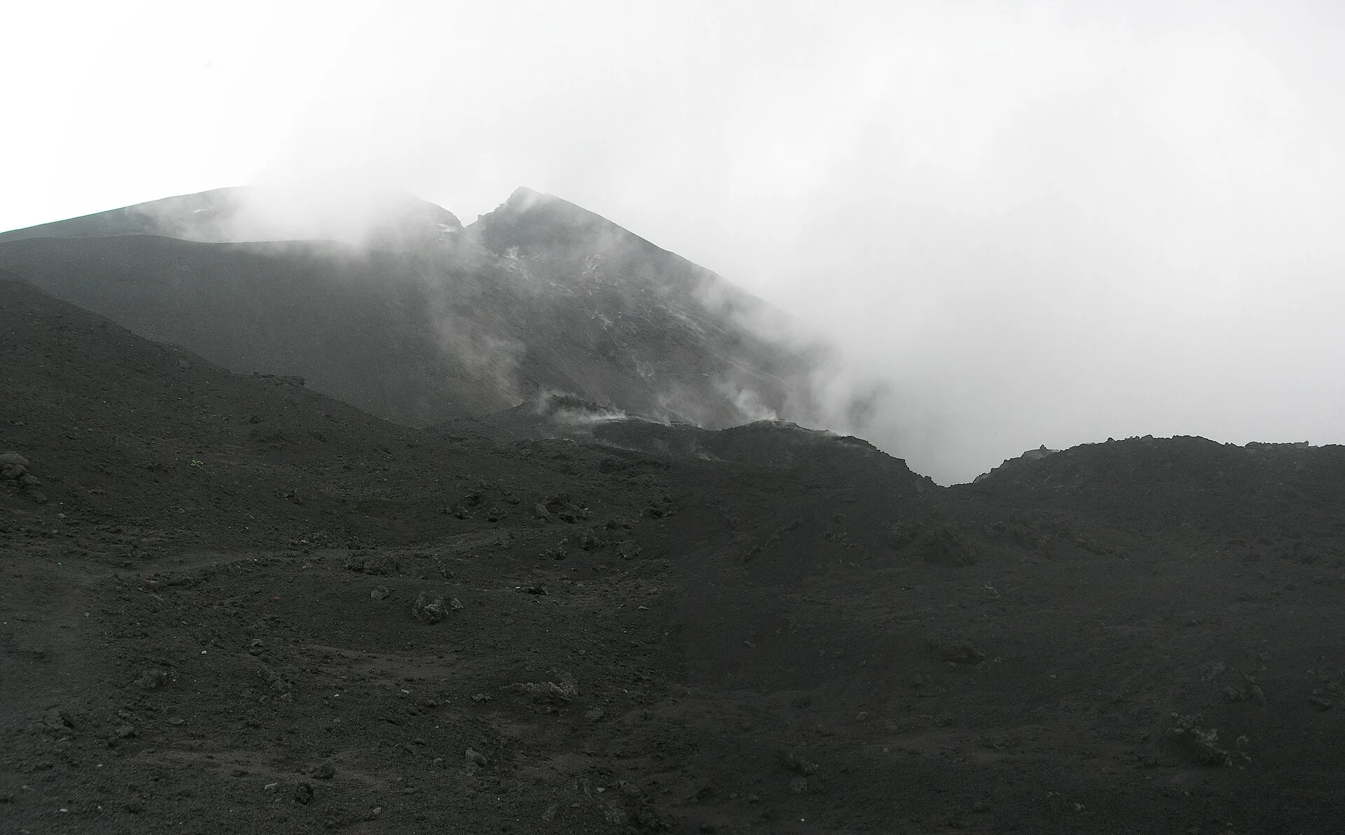
Our Pacaya photo guide keeps the photographic context visible. Past views are labelled as past. They help explain terrain and change over time, but they do not function as a live camera or an invitation to reach the same spot.
Formation and history without a false timeline
Pacaya did not form in one single eruption. Its complex grew through many events. A younger cone can sit within a much older volcanic setting. A date attached to one feature is not necessarily the birth date of every hill or lava field you can see.
The formation guide explains the sequence and the sources behind it. Here, the useful distinction is between the regional volcanic setting and the later growth of individual cones. Keep them separate when reading short descriptions that use one age for the whole place.
The Smithsonian record is also a record of evidence. Some events have detailed reports, while older events can have less precise dates. A catalogue of eruptions and a visitor history are not identical. One may focus on activity at the vent; the other may focus on the impact on nearby roads and towns, or travel.
Past activity is not a daily forecast
The fact that an event happened before does not give a timetable for the next event. Nor does a quiet photo show that every part of the volcano is safe to enter. Treat both dramatic and calm images as records of a moment, not forecasts.
When you read a report, look for the event date first. Then look for the report's issue date. A later article can describe a much earlier event. The date on a web page may be the date the page was updated, rather than the day of the eruption it discusses.
That distinction is especially useful when searching for “last eruption”. A search result can show a recent crawl date beside an old report. Use the Pacaya eruption reference to follow the source trail and the limits of the details we could retrieve. Do not infer a current all-clear from the absence of a new search result.
A dated satellite view as a worked example
NASA's Pacaya Heats Up report was published on 7 April 2021. It describes a Landsat 8 image acquired on 29 March 2021. The report uses a false-colour view to make a heat signal easier to distinguish. It also supplies an earlier natural-colour view for context. Checked October 2026.
That is a useful example of several dates attached to one source. The image has an acquisition date. The story has a issue date. The page can also carry a later update date. Moving from one to another without saying so would turn an old event into a false current claim.
False colour is a science display choice, not the colour a walking visitor should expect to see. A bright feature in that image does not name an allowed viewpoint or a path. To use the image well, first read which bands it combines and what the caption says they show.
For a visitor, the right use of this record is to understand an episode in the volcano's history. It is not a reason to choose a current tour for that same scene. Keep the event in its date, then ask separate questions about today's route. This approach lets the history remain vivid without letting it become a misleading sales promise.
Activity details and access are separate
INSIVUMEH monitors volcanic activity. CONRED publishes disaster-risk details and public recommendations. Park management deals with visitor access. Their roles overlap in a visitor's planning, but their documents do not all answer the same question.
The INSIVUMEH daily bulletin page was checked in October 2026. The retrievable page did not supply a current dated Pacaya bulletin in its text. This guide therefore does not claim a current activity state from that page. An empty bulletin view is not evidence that nothing is happening.
Check the CONRED bulletin entry point as well as the park's instructions. Read the actual notice and its date. A general recommendation about volcano visits is distinct from a notice naming a closed route. Follow the narrower instruction when it applies to your intended visit.
A useful source check before departure
Find the latest actual document you can open, rather than relying on a snippet. Check that it names Pacaya. Record its date and the period it describes. If the document is about another volcano, do not transfer its alert or access rule to Pacaya.
Then ask the park or guide about the route for your day. Confirm the entrance, allowed endpoint and any restriction that affects your group. If the answer is unclear, do not treat a paid reservation as the missing permission. Ask for the uncertainty to be resolved before travelling.
Keep a fallback for the day. That might mean another activity at your base or a later attempt, depending on your plans. It does not mean seeking another informal path around a closure. A closed route is a reason to revise the visit, not a puzzle to solve on the ground.
Height, walking ascent and altitude
The height of a volcano above sea level is not the amount you climb on a walk. The starting point is already above sea level. The allowed endpoint may be well below the top. The ascent on a route is the uphill gain between its points, including any extra rises along the way.
This matters when comparing tour descriptions. One may quote the summit elevation as a place fact. Another may quote the distance walked. Neither figure tells you the other's meaning. Ask what the number measures before using it to judge the effort.
The Pacaya altitude reference compares the heights reported by sources and explains the measurement limits. Do not average two source heights to invent a more precise result. Use the named source's figure for its stated purpose, with its qualification beside it.
Ask about the actual walk
Request the route's starting point and endpoint. Ask whether the walking distance is one way or return. Find out whether the stated time means moving time, time on foot with stops or the whole excursion from town. These definitions prevent more confusion than a single headline number.
If the guide expects to adjust the route on the day, ask what that means for the group. A changed endpoint may alter the distance and effort. That can be the right response to restrictions or conditions. It should not be sold as a guarantee of the original trip plan.
Avoid treating another traveller's pace as a test of your own. The walk can feel different on another route or surface, or the weather. Choose a group plan that allows honest discussion of your pace. A private vehicle alone does not establish that flexibility on the trail.
What a visit can involve
The protected-area setting includes walking routes and views across volcanic ground. The exact route and views depend on what is permitted and what can be seen. Some visitors mainly want to understand the terrain. Others want a guided walk as part of a short stay in the region.
Choose the reason for your trip before you compare packages. If you want the walk, focus on the guide and route. For a named food experience, focus on its seller and permission. If you want time in thermal pools afterwards, confirm the separate venue and transfer.
Do not let one extra obscure the basic plan. You still need transport to the right starting point and an agreed return. You still need to know who is leading the walk. An appealing meal or pool image does not answer those questions.
Ground and footwear
Read the route description for the surface as well as the grade. A path through soil, loose material and old volcanic rock can ask more of your footing than a paved walk of the same length. Ask the guide what kind of shoes it recommends for the actual route.
Try your shoes before the trip and choose a pair that stays secure on your feet. Bring the socks you intend to walk in. If you need poles or another aid, check whether the supplier allows or supplies it. Do not assume that gear shown in a promotional photo is included.
Keep your hands free enough to manage your bag and the terrain. Store loose items before walking on rough ground. Stop at a suitable place when you want to take a photo. The goal is to enjoy the place without making a camera or phone the reason you lose track of the path.
Clothing and what to carry
Pack for the walk you have agreed, with room for a layer and rain protection. Ask the guide how conditions may differ between the starting point and exposed ground. The weather at your hotel is not a measurement of the weather at the trail's highest point.
Carry water and the food you need for the time away. Check whether the supplier includes a snack or meal, but keep that answer separate from water for the walk. A listed lunch at a later venue does not mean you will have food during an earlier delay.
Protect items that should stay dry. Keep your confirmation, local contact and any essential personal items within reach. A simple bag that you can carry comfortably is more useful than a long gear list copied from a distinct mountain trip.
Plan the hike and the arrival together
Start with where you will sleep the night before. Then choose a departure that serves that base. Work forward from pickup to the park and back to your next real commitment. This gives you a plan you can check, rather than several attractive bookings that do not connect.
If you arrive in Guatemala on the same day, leave the arrival process room to run late. A flight's scheduled landing time is not the time you reach a meeting point outside. Ask a private supplier how it handles a delay. A fixed group departure may not be able to wait.
If you travel on after the excursion, ask whether your luggage can go in the vehicle and where the day ends. A return to your original hotel may not suit an onward bus or another town. Confirm any changed endpoint before you pay for the tour.
Keep the return as clear as the pickup
Ask where the vehicle waits while you walk. Confirm who leads the group back to it. If you book transport and guiding on their own, each seller should know the handover plan. One should not assume the other will make the missing connection.
Do not arrange a return based only on an optimistic walking time. Time at the entrance, stops and a route adjustment can all affect the day. Ask what happens if you need to turn back earlier than the group. A group ticket may not include a separate vehicle.
Keep the contact details offline and make a plan for a missed meeting. Agree where to wait rather than improvising a new walking route in search of the driver. The more clearly the day is arranged, the less you need to depend on a phone signal at the end.
How to read a tour offer
A clear offer names the starting base, pickup scope and return point. It describes the guide and language for the walk. It tells you whether park entry is included. It also explains what happens if the supplier cannot run the trip.
Read the included and excluded services together. A short list of highlights may leave the entry ticket out. A statement about a bilingual driver may not cover the walking guide. The useful answer is the one that applies to your exact service and date.
For now, use the site's tour pages to compare those decisions. This publication does not take payment, issue tickets or operate the excursions. It should help you ask better questions of the supplier, without blurring the line between independent details and a booking record.
Shared or private
A shared trip can suit a visitor who can use a set departure and walk with a group. Ask how the group forms and where everyone meets. If you have a strict pace or return need, raise it before booking. Do not wait for the guide to discover it on the path.
A private plan can make the pickup and timing easier to discuss. Ask whether “private” applies to the vehicle or guide, or both services. Check the passenger count and the space for bags. Confirm whether a quoted amount is for the party or for each person.
Private does not mean unrestricted. The group still follows park rules. The vehicle still uses roads that may have delays. The guide still needs to work within the permitted route. Pay for the service that fits you, rather than for an implied exemption from those limits.
Nearby volcano choices
Antigua is a base for several distinct volcano trips. A view of a volcano from town is not the same as a walk on it. A walk aimed at viewing a nearby active volcano is not the same as entering that volcano's crater. Product names can compress those distinctions.
Before comparing trips, write down the time you can give them and the kind of effort you want. Ask which mountain the group walks on and which one it hopes to see. Confirm where the night is spent if the trip includes camping. A dramatic night image can otherwise hide a very distinct trip plan.
Use the nearby guide to place those choices in context. Pacaya can be the right fit for one set of plans and a poor fit for another. The useful recommendation is conditional on your time, the route and the group's needs. It is not a claim that one volcano is best for everyone.
The park as a protected place
The Pacaya National Park guide explains the park setting and the institutions named by sources. A protected-area boundary is not the same as a visitor route. You may be able to enter one part while other ground remains off limits.
Follow the agreed path and the guide's instructions. Leave rock and plants where they are. Take your rubbish back to a proper disposal point. Ask before using gear that may have its own rules, such as a drone. A tour ticket should not be read as permission for every activity.
Treat people working in and around the park as sellers of specific services. If you want another service, ask the cost and terms before accepting it. Keep the park entry payment separate from a guide payment or an optional extra. Clear agreements are better than assumptions made in a hurry at the entrance.
Reading the dates and sources on this guide
“Checked October 2026” means the source was read then. It does not mean the source's underlying measurement was made that month. A past picture retains its capture date. A report retains its event date even when it is linked from a newly updated page.
Look at the source's job before using its facts. A database is suited to eruption history. A park administration is the right place to settle access. A supplier can explain what its package includes. One should not silently stand in for another.
Some questions remain open when the available source is incomplete or old. This guide says so instead of filling the gap with a plausible number. If you find a dated primary notice that changes a page, send the page address and that notice through Contact. The editorial question is whether the new evidence answers the same claim.
Reading volcanic ground without leaving the route
You can learn from the terrain without collecting a rock or stepping into a vent. Ask your guide which features the route passes. A useful explanation connects a feature to a known source or event. It should also say when the age or origin is not clear from sight alone.
Look at the size of features from a permitted viewpoint. A cone is a large landform. A crack in a lava surface is a much smaller feature. A photo can make both look similar when it lacks scale. Keep a path, a known object or a distant ridge in a picture if you want to remember the relative size later.
Do not use colour alone to judge heat. Dark rock can be old or recent, and a photo may record colour quite differently from what your eye sees. The guide's permitted route and the authority's instructions matter more than your guess from appearance. A place can be hazardous without looking dramatic.
From magma to a lava field
Magma is molten rock below the surface. The term changes to lava when it reaches the surface. As the material cools, it can leave a solid flow with a surface that differs from the rock beneath. The visible outer crust is therefore only part of the feature.
The US Geological Survey's eruption explanation describes how gas and the properties of magma affect eruptions. Some activity produces flows; other activity throws material into the air. This general science helps explain the terms in a report. It does not diagnose the state of a specific patch of ground at Pacaya.
The visitor lesson is to avoid a false choice between “lava” and “no volcano”. A solid field still records a volcanic event. An account of a walk can be interesting without an active flow. If your only reason to book is a guaranteed eruption, the offer cannot give you what you want.
Why a regional map helps
A regional map shows how places relate to each other. A road map helps connect towns and entrances. A trail map describes a walking route. A volcanic hazard map answers a distinct question again. Keep the map's purpose in view before using it to make a decision.
For example, a line from a city to a volcano on a locator is not a road. A boundary on a hazard map is not necessarily a tourist trail closure. A label naming a peak is not a drop-off point. Read the legend and source date before you interpret the marks.
Use a printed or saved map as a backup to the meeting instructions, but do not invent a route from it. If the guide's meeting point differs from the map app's place pin, resolve that before leaving town. A few minutes spent checking the named point can prevent a confused arrival at the wrong side of the area.
A place in Guatemala's volcanic setting
Pacaya belongs to a much wider volcanic region. That does not make every Guatemalan volcano the same kind of place to visit. Distinct peaks have distinct routes and records, plus access plans. One attractive trip plan cannot stand in for all of them.
If you want to know how many volcanoes are in Guatemala, begin with what a source counts. A list of volcanic centres may differ from a list of named peaks. A tourist list can have a distinct purpose from a database. A count is only useful when its definition is clear.
That same care applies to words such as “active”. Ask which definition the source uses. A catalogue may use a long geological period, while a daily report describes observed activity over a short period. Neither should be reduced to a simple promise that a visitor will see an eruption on a chosen afternoon.
Keep the visit narrow enough to enjoy
A short stay can become crowded if every available excursion is added to it. Choose the part of Pacaya that most interests you, then allow time for that visit to work. Avoid building a day that depends on every pickup and road section running at its fastest possible pace.
If you want a slower walk, tell the supplier before joining a set group. If you prefer a quick return, check whether the service can actually deliver one. A guide needs to know the group's constraints. A vague request to “go early” may not cover your real concern.
You can also leave room to see the place without adding every marketed extra. A guided walk and a clear return can be a complete day plan. A food stop or thermal circuit can fit when it serves your interests and the timing works. The right plan is the one you understand well enough to book with clear expectations.
Travel choices for distinct party needs
The party you travel with affects the service you need. A solo visitor, a pair and a larger group may compare the same headline offer differently. Check how the price is charged and how the guide is assigned. Do not assume that the service grows in the same way as the passenger count.
For a group, choose one person to keep the written plan. Share the meeting point and return details with everyone. Make sure the supplier has the full party size and any needs that affect the vehicle or walk. Splitting the details across several messages can leave each person with a distinct version.
If the party may split during the day, ask whether that is possible under the guide plan. An early return for one person can require another guide or vehicle. Agree the options before the walk rather than assuming the group can divide whenever it wants.
Travelling with children
Ask the supplier about its age policy and the route it uses with children. A label such as “family friendly” does not answer how long the group walks, where it can stop or what happens if a child needs to turn back. Give the guide the ages and needs of your party.
Choose a plan that adults can manage without relying on an optional service being available. If a supplier mentions horses, ask who operates them, which section they cover and how the service is charged. Do not treat a horse as a guaranteed substitute for a walk unless the exact plan is confirmed.
Food and rest need their own thought. An adult's snack may not suit a child, and a later included meal may be too late for your party. Carry what you need for the day you have agreed. Keep the route and the return simple enough that the plan still works if the pace is slow.
Mobility and other personal requirements
Ask for specific route facts instead of a broad difficulty label. Find out about steps, loose ground and steep sections. Ask where a vehicle can stop and which part must be walked. A supplier should not need to guess what you mean by “easy access”.
State the requirement that matters to you. That may be a place to sit, a slower pace or a limit on uneven ground. Ask what the supplier can confirm and what it cannot. If it cannot give enough detail, do not turn the lack of an answer into an assumption that the route will suit you.
This is a planning discussion, not a personal fitness test. A general guide cannot decide whether you should walk a specific route. Clear details about the actual surface and effort lets you make a more informed choice. It also helps the supplier name when its usual group plan is a poor match.
Prices and the difference between costs
A tour price, park entry fee and guide fee are distinct charges. Some packages combine them; others leave one or more payable at the entrance. An optional meal or horse service adds another charge. A total only means something when the included services are clear.
Ask whether a quote is per person or per group. Check the currency and the method of payment. If a seller gives a price in another currency, ask which amount is actually charged. Do not convert an old tariff and present the result as today's park cost.
Request a written list of any likely extra payment before departure. That gives you a way to compare the real service rather than the smallest number in an advertisement. It also makes it easier to spot when two offers cover distinct parts of the day.
Keep a booking record that is useful on the ground
Save the exact product name and the supplier's name. Keep the date, party size and pickup address in the same record. Add the return point and the included services. The aim is to have one short plan you can show if there is a misunderstanding.
Store the local contact and the terms for cancelling offline. Keep a copy of any answer that changes the standard package. If the supplier agrees to a distinct pickup or a dietary request, that answer should be easy to find. A long thread with the useful detail hidden in the middle is hard to use at the meeting point.
When you receive the final reminder, compare it with the plan you saved. Check for a changed time or entrance. Resolve a mismatch before travelling rather than assuming it is only a wording difference. If the supplier changes a material service, ask how that affects your options under the terms you accepted.
Photos, expectations and responsible use
A volcanic photo can be accurate and still give a misleading expectation when its date is missing. A lava scene from an eruptive period may be shown beside a current tour. A view from a restricted point may appear without explaining that today's route is elsewhere. Read the caption before building your plans around the image.
For your own photos, stay within the permitted route and pause where it is appropriate. Ask before taking close photos of a guide or worker, or another visitor. Keep clear of the group's path while using your phone. A good picture is not worth leaving the instructions behind.
This publication uses real licensed photos when showing a recognisable place. Generic trip-preparation images are kept separate from evidence of terrain or volcanic activity. The credit names the photographer and licence. A past image is a record to understand, not a preview of the exact conditions you will find.
Weather plans and time of day
Choose a time of day for the visit you can actually arrange. A sunrise plan needs an allowed start time and an agreed route in darkness. A sunset plan needs a clear descent and return plan. A regular daytime walk may be easier to fit around transport, but it still needs a current weather and access check.
Do not confuse the pickup time with the time you reach the viewpoint. The drive and the walk come between them. Ask which part the supplier times to sunrise or sunset. If it cannot name that point, the label may tell you less than it appears to.
Cloud can hide a view even when the walk goes ahead. Rain can affect the surface without making the whole day a washout. Wind can make an exposed stop feel distinct from the start of the path. Ask the guide how it decides whether to shorten the route or wait, or cancel.
Forecasts and seasonal advice
A seasonal pattern describes a broad tendency across many days. A forecast concerns a shorter period and a defined place. Neither is a guarantee of clear views. Use seasonal advice to plan the broad trip, then use a relevant forecast and local instructions near departure.
Check the location behind a weather forecast. A city forecast, a mountain grid point and an airport observation may describe distinct conditions. A temperature without a place and height is not enough to choose every layer you will wear. Ask the guide about the exposed part of the actual walk.
Keep your plan flexible in a practical way. Know the supplier's terms for cancelling before the forecast causes concern. Pack the agreed rain layer and protect the items that need to stay dry. If conditions lead to cancellation, use the alternative day plan rather than trying an unconfirmed route with another person.
The last check at the meeting point
Before the group sets off, confirm the day's route and the return meeting point. Ask whether anything has changed since the booking. A guide may have details that was not available when you reserved. Listen to that update before treating the printed trip plan as a fixed contract with the mountain.
Check that your party has the gear it agreed to bring. Put a light within reach if the return may be after dark. Keep water where you can reach it without emptying the bag. A short pause to sort these details is more useful than discovering them on a narrow part of the path.
If you do not understand an instruction, ask for it again in plain words. Confirm any hand signal or meeting instruction the group will use. The point is not to guess the guide's meaning from context. A clear shared plan matters more than the exact wording in a sales description.
Questions about visiting Pacaya
Is Pacaya the same place as Acatenango?
No. They are distinct volcanoes and distinct trip choices. Do not use a picture from one as evidence for conditions at the other. Check the mountain named in the walking route, the starting base and the time away. The nearby guide helps keep those choices clear before you compare suppliers.
Does a tour guarantee seeing lava?
No. A tour sells a service under its stated conditions. It cannot guarantee a volcanic event. Ask whether “lava” means older solid rock, a hot spot or an active flow in the description. Do not buy a trip that depends on entering closed ground or approaching a hazardous feature.
Is the volcano height the amount you climb?
No. Height above sea level is distinct from the ascent on a walking route. You need the route's start and endpoint, its return distance and the meaning of its stated time. A summit elevation alone does not tell you the work of the walk or the point visitors are allowed to reach.
Can an old park page establish today's hours?
An old page can show what was published, but it does not settle today's access. Check its issue date and scope, then confirm the intended entrance with the responsible source. Do not combine an old opening time with a new tour advertisement and treat the result as a current park notice.
Verdict on planning a Pacaya Volcano visit
Start with the place, then build the day around a permitted route and a clear return. Choose a guide and transport that match where you stay. Treat food and thermal stops as separate services with their own terms. Pacaya Volcano is worth understanding as a volcanic place, without needing a promise of lava to make the plan sound appealing.